Category Archives: Gokyo

Nepal Everest View Trek Gokyo to Lukla

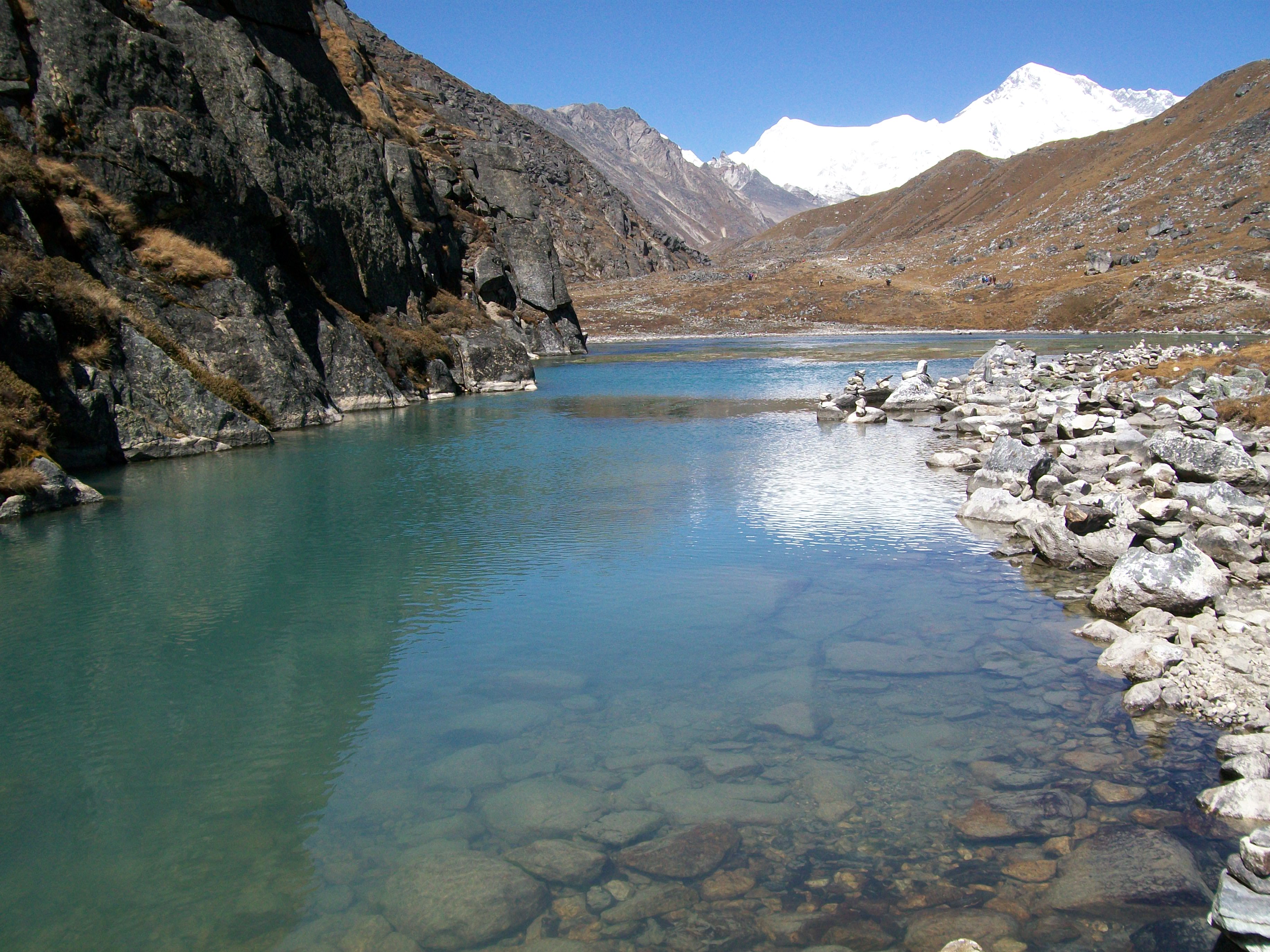
The next day was another relaxing one, and I just walked to the other side of the third lake, where there is a kind of beach. The first photo is looking back at the Gokyo lodges across the lake.

Nepal 119

Gokyo to Pangboche

The next day I started the return journey; returning on the route of the outward trek until Phortse Tanga. Then it was a left turn to Pangboche, where I overnighted at a lodge run by a Sherpa who had climbed Everest several times. There were photos of him on the peak  in the dining room.

The first photo below is of sunrise on the mountains in the morning. Looking up what mountain it is I today, nearly five years later, realised it’s the Everest range from the other side to Gokyo.

Can you spot the horse in the second photo?

The third photo is looking back at Pangboche, with Ama Dablam to its side, and the Everest range behind it.

Nepal 120Nepal 121Nepal 122

Tengboche to Lukla

The first photo below also looks back at Ama Dablam and the Everest range, but from Tengboche, where I overnighted.

The final photo is from Lukla, which is either the trek beginning or end, or both, if you fly Lukla-Kathmandu-Lukla.

Nepal 123Nepal 124Marc Latham’s central site is the Greenygrey (http://www.greenygrey.co.uk), and he has books available on Smashwords and Amazon (http://www.amazon.com/author/marclatham).

Mount Everest and Gokyo Lakes Photos

The day after climbing up Gokyo Ri I walked up to the last two lakes, which were jade rather than turquoise. There was another view of Mount Everest along the way (photos 1 [right side as viewed, looking smaller than Cho-Oyu] and 3 [above Makalu]).

Between the track and Cho-Oyu / Everest was the Ngozumpa glacier: the longest glacier in the Himalayas.

Mount Everest Photos

Nepal 116 Nepal 117 Nepal 118


Marc Latham’s central site is the Greenygrey (http://www.greenygrey.co.uk), and he has books available on Smashwords and Amazon (http://www.amazon.com/author/marclatham).

Mount Everest Views from Gokyo Ri

I had stomach problems in the morning, but was determined to climb Gokyo Ri (5,357 metres, 17,575 ft) to complete the Jiri to Gokyo 100-mile trek, and see Mount Everest. My description of climbing Gokyo Ri is mixed below with photos, and there’s a video from the summit at the end.

Climbing Gokyo Ri

The sunrise looked stunning as it lit up Cho-Oyu on another beautiful clear morning, so I went out to take a photo.

Nepal 109

I left at about 7am.  Stepping-stones crossed the stream running down from the north.  I made it most of the way across, before putting a foot in the water.  It could have been worse: a trekker I later met had fallen back into the water!

The lake looked amazing at the start of the climb, with the sun dipping a copy of Phari Lapche into it, mixing the water between blues and greens, and framing it with the real mountains and an illuminated Gokyo Ri.

reflections

It was a steep climb from the start, and I missed the downhills I’d begun to resent earlier on the trek.  However, any difficulties were outweighed by the stunning scenery being unveiled.

Nepal 110

Looking back down the mountain, from one side of Gokyo Ri to the other, the scenery was one continuous arc of astonishment: the planet’s highest peaks shone under the sun framing turquoise lakes and a moonscape glacier. 

And then I could make Everest out!  It was an amazing feeling to see the highest point on Earth, and fulfil the main objective of the trip.

Nepal 112

I reached the peak after about three hours, completing the mission part of the trek.  It was certainly all worth it, with an amazing 360 degree panorama viewable from amongst the prayer flags and cairns.  There was also a small Buddha statue there.

Nepal 113

The fourth Gokyo lake was visible to the north: it was jade rather than turquoise.  Small brown birds flew around freely, and looked quite tame when they landed.  

Walking down was nice, although a little sad to know it was all over, and the rest of the day was spent relaxing and savouring. 

Marc Latham’s central site is the Greenygrey (http://www.greenygrey.co.uk), and he has books available on Smashwords and Amazon (http://www.amazon.com/author/marclatham).

Everest View Trek Reaches Gokyo Destination

Gokyo village (4750 metres, 15,583 ft) is basically a few guest houses on the banks of the third Gokyo lake. It was the end destination of the trek, about 100 miles from its start point in Jiri. Towering above the lake is Gokyo Ri (5,357 metres, 17,575 ft), which provides excellent views of Everest.

Trekking into Gokyo 

My camera batteries were low, so I only took one photo after reaching Gokyo, so I could take some on Gokyo Ri the next day. That photo of a Tibetan Snowcock follows my description of arriving at Gokyo’s third lake, and the end of the sun for the day:

The third lake was not far away, and it was a delight to see it on the track’s left at about 1pm.  I washed my face in the water, and threw a stone in to celebrate.  Gokyo Ri towered above the lake to the north.  The village was straight ahead, on the eastern edge of the lake.

Some mist started coming off the lake at about 3.30pm, and more cloud drifted down from the north.  The sun started setting above Phari Lapche and Chadoten mountains just after 4pm, and disappeared behind thick cloud over the mountains at about 4.30.

Nepal 108

Nepal Everest View Gokyo Lakes Photos

Alpine snowdrops lit up the ground, mirroring the sunny clear sky. Then, ten days into a Jiri-Gokyo trek, the first Gokyo lake came into view.

Gokyo Lakes Nepal Photos

It was great to reach the first Gokyo lake, and I built a cairn amongst many.

The fourth photo is of Cholatse, with its distinctive steep northern face.

I climbed over a couple of rocks to get the fifth photo of Gokyo’s second lake from its southern end. On its northern edge are the orange tents of a climbing group. Cho-Oyu is in the distance, as it is in the second photo.

Nepal 100 Nepal 102 Nepal 103 Nepal 106 Nepal 107Marc Latham’s central site is the Greenygrey (http://www.greenygrey.co.uk), and he has books available on Smashwords and Amazon (http://www.amazon.com/author/marclatham).

Nepal Everest View Trek: Machhermo

My Stockholm article from the Norway – Sweden trip that ended the twenty-five years of travel featured in this blog, and started off this blog, has now been published on travelthruhistory.com. The main article in this month’s issue of the website is about Kathmandu, Nepal

Kathmandu to Gokyo

My Nepal journey started in Kathmandu. I took a bus to Jiri and trekked for about a week to the Everest national park. I had now reached Machhermo, a day away from the target destination of Gokyo.

A night trip to the outside toilet revealed a clear sky full of stars. Moreover, the mountains were silhouetted, and I tried to take a photo of them.

Machhermo Photo and Video

Nepal 092

The sunrise lighting up the mountain peaks in the morning, above frosty fields of yaks, inspired a video:

Machhermo to Gokyo Photos

I also took some photos, posted below, starting with Machhermo Peak from the village in the morning.

The second photo looks back down the valley, with Thamserku and saddle-peak Kangtega in the middle distance.

The steep sided mountain in the third and fifth photos is Cholatse. Its southern neighbour is Taboche. A hiker passes a yak herd in the fifth.

All five of those mountains are between 6000 and 7000 metres. Everest is about 8800 metres.

The fourth photo is of the Dudh Koshi river, running through the valley.

It was a few hours of enjoyable walking to Gokyo, and the next blog will feature photos of Gokyo’s lakes as the destination is reached.

Nepal 093 Nepal 096Nepal 097Nepal 098Nepal 099Marc Latham’s central site is the Greenygrey (http://www.greenygrey.co.uk), and he has books available on Smashwords and Amazon (http://www.amazon.com/author/marclatham).

Nepal Everest View Trek Photos

After an easy second day on the Nepal Jiri-Gokyo trek the third day was as hard as it looked from Kinja, with a long steep climb the only way out of the village in our direction. In the morning, after the previous day’s cloud dissipated, snow-capped mountains were visible. Mule trains passed on the hike.

Kinja to Goyom Everest View Trek

The long incline levelled off entering Sete. After lunch there, the route led upwards again, when the other direction along the valley was flat!

The path was nicely tree-lined, but emerging from cover at Dakchau it was raining. The rain kept up, so a warm fireplace at Goyom was very inviting, and that was the end of the third day. Here’s some photos:

Nepal Himalayas Photos

Nepal 034 Nepal 035 Nepal 036 Nepal 037

Marc Latham’s central site is the Greenygrey (http://www.greenygrey.co.uk), and he has books available on Smashwords and Amazon (http://www.amazon.com/author/marclatham).

Jiri – Gokyo Nepal Trek Shivalaya Photos

The first day of the 100-mile Jiri-Gokyo Everest views trek was a tough three mountains rollercoaster, with lots of steep inclines and declines; I think over the highest peak in the first photo: in the left hand corner as viewed.

Nepal Trek Shivalaya Photos

Shivalaya was reached around lunchtime, and the woman in the fourth photo provided a free tea. The day’s hike ended by torchlight in Bhandar after dark. There were lots of ‘namaste’ greetings along the way. Here’s some photos:

Nepal 017 Nepal 020 Nepal 022 Nepal 023 Nepal 024 Nepal 025 Nepal 026 doorway2

Marc Latham’s central site is the Greenygrey (http://www.greenygrey.co.uk), and he has books available on Smashwords and Amazon (http://www.amazon.com/author/marclatham).