Monthly Archives: February 2014

Everest View Trek Reaches Gokyo Destination

Gokyo village (4750 metres, 15,583 ft) is basically a few guest houses on the banks of the third Gokyo lake. It was the end destination of the trek, about 100 miles from its start point in Jiri. Towering above the lake is Gokyo Ri (5,357 metres, 17,575 ft), which provides excellent views of Everest.

Trekking into Gokyo 

My camera batteries were low, so I only took one photo after reaching Gokyo, so I could take some on Gokyo Ri the next day. That photo of a Tibetan Snowcock follows my description of arriving at Gokyo’s third lake, and the end of the sun for the day:

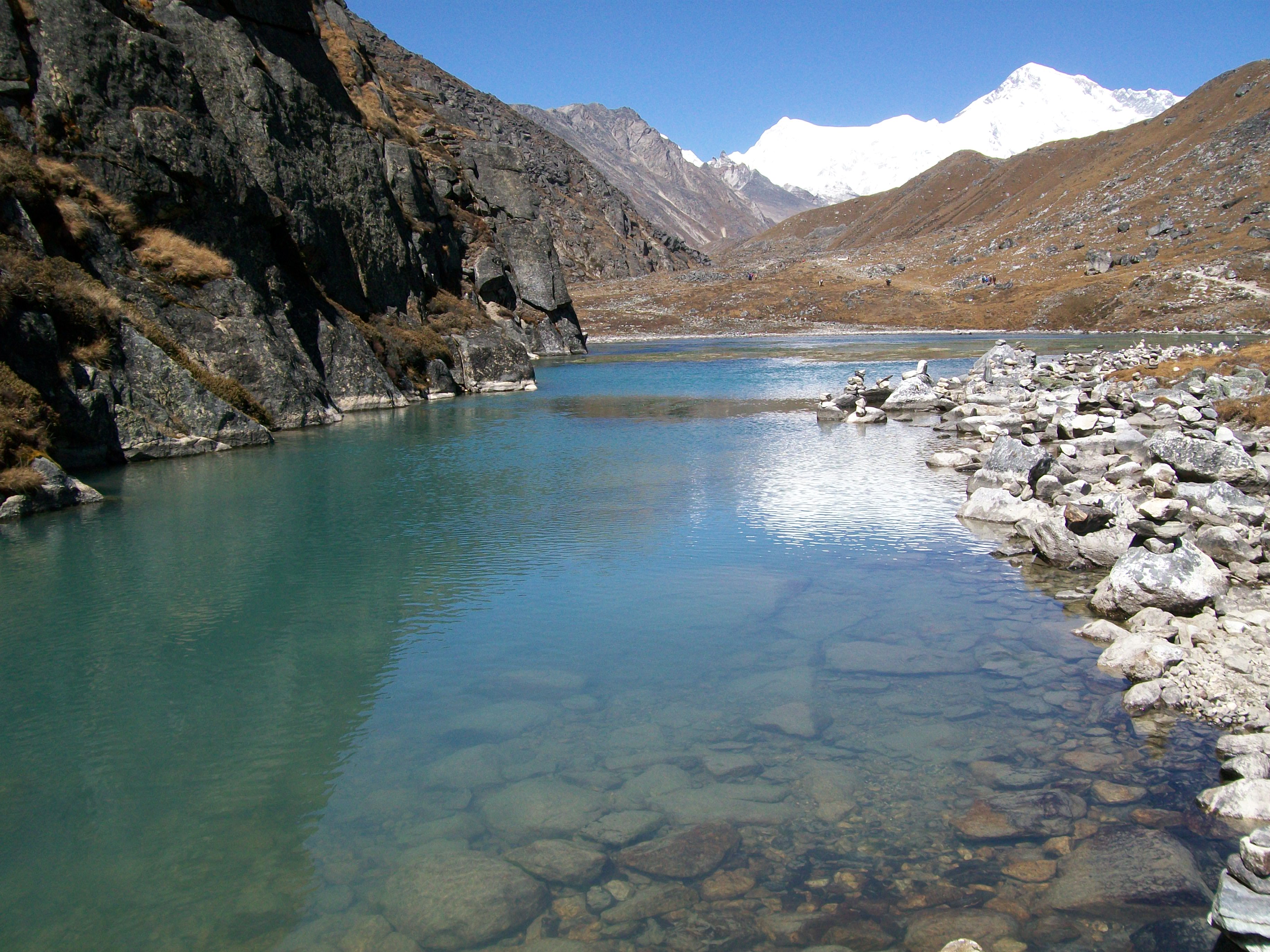
The third lake was not far away, and it was a delight to see it on the track’s left at about 1pm.  I washed my face in the water, and threw a stone in to celebrate.  Gokyo Ri towered above the lake to the north.  The village was straight ahead, on the eastern edge of the lake.

Some mist started coming off the lake at about 3.30pm, and more cloud drifted down from the north.  The sun started setting above Phari Lapche and Chadoten mountains just after 4pm, and disappeared behind thick cloud over the mountains at about 4.30.

Nepal 108

Nepal Everest View Gokyo Lakes Photos

Alpine snowdrops lit up the ground, mirroring the sunny clear sky. Then, ten days into a Jiri-Gokyo trek, the first Gokyo lake came into view.

Gokyo Lakes Nepal Photos

It was great to reach the first Gokyo lake, and I built a cairn amongst many.

The fourth photo is of Cholatse, with its distinctive steep northern face.

I climbed over a couple of rocks to get the fifth photo of Gokyo’s second lake from its southern end. On its northern edge are the orange tents of a climbing group. Cho-Oyu is in the distance, as it is in the second photo.

Nepal 100 Nepal 102 Nepal 103 Nepal 106 Nepal 107Marc Latham’s central site is the Greenygrey (http://www.greenygrey.co.uk), and he has books available on Smashwords and Amazon (http://www.amazon.com/author/marclatham).

Nepal Everest View Trek: Machhermo

My Stockholm article from the Norway – Sweden trip that ended the twenty-five years of travel featured in this blog, and started off this blog, has now been published on travelthruhistory.com. The main article in this month’s issue of the website is about Kathmandu, Nepal

Kathmandu to Gokyo

My Nepal journey started in Kathmandu. I took a bus to Jiri and trekked for about a week to the Everest national park. I had now reached Machhermo, a day away from the target destination of Gokyo.

A night trip to the outside toilet revealed a clear sky full of stars. Moreover, the mountains were silhouetted, and I tried to take a photo of them.

Machhermo Photo and Video

Nepal 092

The sunrise lighting up the mountain peaks in the morning, above frosty fields of yaks, inspired a video:

Machhermo to Gokyo Photos

I also took some photos, posted below, starting with Machhermo Peak from the village in the morning.

The second photo looks back down the valley, with Thamserku and saddle-peak Kangtega in the middle distance.

The steep sided mountain in the third and fifth photos is Cholatse. Its southern neighbour is Taboche. A hiker passes a yak herd in the fifth.

All five of those mountains are between 6000 and 7000 metres. Everest is about 8800 metres.

The fourth photo is of the Dudh Koshi river, running through the valley.

It was a few hours of enjoyable walking to Gokyo, and the next blog will feature photos of Gokyo’s lakes as the destination is reached.

Nepal 093 Nepal 096Nepal 097Nepal 098Nepal 099Marc Latham’s central site is the Greenygrey (http://www.greenygrey.co.uk), and he has books available on Smashwords and Amazon (http://www.amazon.com/author/marclatham).

Machhermo Nepal Medical Centre Information

The Norway third episode of the Channel4 Scandimania television series started off in Bergen and then travelled to Voss and Bergen by train like Marc Latham on his Norway-Sweden journey that ended his twenty-five years of travel and started this blog. It’s available from the link above, but just in the U.K. I think.

Dhole to Machhermo

After two nights and a day in bed, I managed breakfast before setting off on the last full day of trekking from Jiri to Gokyo. I went straight to the toilet afterwards, but the sickness had mostly passed, and I didn’t need the toilet again.

My previous travels had told me it was just mild food poisoning, with a lunch stop between Namche and Dhole the likeliest source. The first night had been feverish, while the next day and night were just tiredness and recovery.

Machhermo Altitude Centre

After an initial incline the day’s trek was quite steady, with great views over the valley below and up to the mountains above them.

Arriving in Machhermo (4400 metres) around noon I went to an informational presentation put on by the medical centre about avoiding altitude sickness at 3pm.

It was an entertaining talk, and they tested a full room of trekkers for oxygen saturation. Everyone was okay. A new medical student had been helicoptered out that afternoon with altitude sickness!

Everest View Trek Photos

The first photo below was from the previous day’s trek, between Namche and Dhole. The colours reminded me of the U.K., and the autumn underway there.

The mountain at the end of the valley in the lower photos is Cho-Oyu, which is the sixth highest mountain in the world. It marks the border between Nepal and Tibet/China. I didn’t know that at the time, or that Gokyo was before it.

I think it is Machhermo visible below the hikers in the last photo.

Nepal 086 Nepal 087 Nepal 089 Nepal 090 Nepal 091


Marc Latham’s central site is the Greenygrey (http://www.greenygrey.co.uk), and he has books available on Smashwords and Amazon (http://www.amazon.com/author/marclatham).

Ama Dablam and Khumjung Photos on Nepal Trek

Leaving Namche Bazaar (3400 metres) at dawn it was quite a steep short hike up the mountain above and then down to green-roofed Khumjung. From there Ama Dablam was visible. It is widely regarded as the most beautiful of the Everest park mountains, and I agree.

Ama Dablam reminds me of the sphinx. The first three photos below are of the mountain and Khumjung.

Namche Bazaar to Dhole

From Khumjung it was another tough climb over the Mong-La pass, before a downhill to match, and then a steady up and down walk to Dhole (4040 metres). Some of it was through forestry.

After finding a lodge I started feeling ill after ordering food! I was bed-ridden with stomach and sickness problems for the next day.

Nepal 080 Nepal 081 Nepal 082 Nepal 083

Nepal Everest View Trek Reaches Namche Bazaar

Phakding is a nice village with a river running through, and mountains around it. It seemed wealthier than the villages previously visited, and that’s probably because it gets the custom of all the hikers that fly into Lukla.

I recommend taking the bus from Kathmandu to Jiri and hiking from there if you have the time, and inclination, as it’s beautiful scenery and the villages probably need the custom. You can always fly back from the ‘most dangerous airport’ in the world, as I did.

Phakding – Namche Bazaar

At the top of Phakding, the mountain view went from great to amazing, as Thamserku came into view (first photo). It was the first of the mountains that would be in view for most of the trek to Gokyo, marking the southern entrance.

The path led across the bridge in photo 2 and then down to the river itself. It was then a long uphill to Namche Bazaar: the entrance point to the Sagarmatha (Everest) national park.

Namche Bazaar Mountains and Market

Namche is recommended as a two-night stop on the trek, to get used to the altitude, and recover a little. Waking early the next morning I went out to see the sunrise (photos 3-6), which had started lighting up the mountains across the valley, but not the ones behind the town: such as Thamserku. I stayed in the Thamserku View hotel.

The bazaar was setting up as I returned, and I visited it later (photo 7).

Nepal 072 Nepal 073 Nepal 074 Nepal 075 Nepal 076 Nepal 077 Nepal 078


Marc Latham’s central site is the Greenygrey (http://www.greenygrey.co.uk), and he has books available on Smashwords and Amazon (http://www.amazon.com/author/marclatham).

Jiri to Gokyo Everest View Himalayas Trek

Paiya proved to be the end of the quiet trek, as there was a group of climbers camping there, and on the seventh day from Paiya to Phakding trekkers that had flown into Lukla joined the path to the Sagarmatha (Everest) park at Chheplung.

Paiya to Phakding Himalayas Photos

The first two photos are from Chheplung. Didn’t see any red pandas I’m afraid. The fourth is from Phakding.

After mostly cloud and rain for a week, the sky was mostly clear on the eighth morning: the morning of arrival in the Sagarmatha park, and views of the really high peaks.

The monsoon had passed, and it would be mostly clear skies for the rest of the trek, providing perfect conditions for viewing the Everest park and taking photos.

Nepal 068 Nepal 069 Nepal 070 Nepal 071

Marc Latham’s central site is the Greenygrey (http://www.greenygrey.co.uk), and he has books available on Smashwords and Amazon (http://www.amazon.com/author/marclatham).

Nepal Everest View Trek Dudh Koshi Photos

On the sixth day of a Nepal Himalayas Everest trek from Jiri to Gokyo, leaving Nunthala it was downhill to a bridge above where the Deku Khola and Dudh Koshi rivers met.

Nepal Everest View Trek Photos

The first photo looks back at the Deku Khola valley, and the second was the view ahead, up the Dudh Koshi valley. Then it was uphill to Paiya.

Along the way, I happened upon a battle between a tarantula hawk (pompilid) and a tarantula; and later on a lighter note, a colourful bird in forestry.

Nepal 058Nepal 066Nepal 059Nepal 063Nepal 065hornet6bNepal 067tham danda CU


Marc Latham’s central site is the Greenygrey (http://www.greenygrey.co.uk), and he has books available on Smashwords and Amazon (http://www.amazon.com/author/marclatham).

Junbesi to Nunthala on Jiri – Gokyo Everest Park Trek

Leaving Junbesi on the fifth day of a Jiri-Gokyo trek I took a photo of the monastery visited the previous day. It was then a downhill before crossing the Taktor Khola valley to Ringmu. The previous afternoon’s trek was visible from the cafe I had lunch at with a few Europeans who’d also left Junbesi that morning. A stupa and prayer flags brightened the greenygrey valley view. Then the path led up to Taksindu. A waterfall and puppies led down to Nunthala, and the end of the day’s trek.

Everest View Nepal Trek Photos

Nepal 051 Nepal 054 Nepal 055 Nepal 056


Marc Latham’s central site is the Greenygrey (http://www.greenygrey.co.uk), and he has books available on Smashwords and Amazon (http://www.amazon.com/author/marclatham).